Land Yacht

Land Yacht
Ernie and Bert

Sunday, August 30, 2015

Escalante Part 5

On Sunday, August 16th we went to the Escalante Petrified Forest Start Park.  We included the extra loop which made the hike 2 miles.  The loop was a little difficult but well worth the effort!  There are petrified trees all over Utah but there was a high concentration in this area.  There were pieces large and small EVERYWHERE and the colors were amazing!


Wide Hollow Lake which is in the park


Loved the red color


There were LOTS of these big pieces


In the afternoon we walked around Devil's Garden which is a part of Grand Staircase Escalante National Monument.  There is nothing for miles and then all of the sudden there is a grouping of arches and other rock structures.


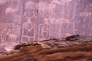
On Monday, August 17th we Took a hike to see more petroglyphs.  On our way we stopped at Kiva Coffee House which had been recommended by several people.  Great coffee and view in a unique building.  It is also a Bed and Breakfast.  


Inside of Kiva Coffee House.  The back wall is built into the side of the cliff, the front is all windows to overlook the canyon


View outside the Kiva Coffee House


They call this 100 hands


Utah 12 as seen from our hike


Wednesday, August 26, 2015

Escalante Part 4

On Saturday, August 15th they had a small but wonderful Farmer's Market on Main Street in Escalante.  Everything that was sold was local, organic and fresh picked that morning.  We enjoyed shopping and eating our finds.  We did another hike.  This hike took us up the Escalante River.  We had to cross the river a total of 14 times.  Our Keen Water Sandals served us well.  Crossing the river also helped cool us off.  The hike was a total of 5 miles.  Our rewards along with enjoying the beautiful scenery were seeing a natural bridge, an arch and an ancient Indian Ruin with petroglyphs.


One of the times Wayne crossed the Escalante River


The poles help you to feel your way across the muddy river


Our first siting of the arch


Natural Bridge


Wayne under the bridge


Loved the colors


Arrived at the arch


It was way up there


Ancient Fremont Indian Ruins high on the cliff


Above and below note the red markings, the Fremont Indians painted their petroglyphs rather than carving them


One last look at the arch


Tuesday, August 25, 2015

Escalante Part 3

On Friday, August 14, to rest up from our hike the day before, we took a drive down Hell's Backbone Road.  It is a dirt road that was in service as the main road between Boulder and Escalante until Highway 12 was completed in 1985.  The owner of our campground said we should really stop at Posy Lake as long as we were going that way. It may be a lake in Utah but I would call it Posy Pond. I did have fun at Posy Pond Trying to get a picture of a Dragon Fly.  There were hundreds of Dragon Flies flying in the flowers. There were also a few bees but they cooperated when I was trying to take a picture.


Posy Lake


Dragon Fly


Bee


Another variety of Bee


 It was a pretty drive. We had a picnic lunch at the point which had nice views, but the best part was the Hell's Backbone Bridge.  You can learn more about Hell's Backbone by clicking  here.


Above and below are from along the side of the road


Above and below views from lunch


Hell's Backbone Bridge coming from Escalante


Standing on the bridge looking West


Standing on the bridge looking East


When we got back on the main road we were back on Highway 12 to get back to the campground so I will give you some more pictures of the views.


This section of Highway 12 is known as The Hog Back (note the lack of shoulder and 1200 foot drop on each side)


Calf Creek Canyon


We walked that trail in Calf Creek Canyon to get to the falls